The courses
The BikeRun XXL
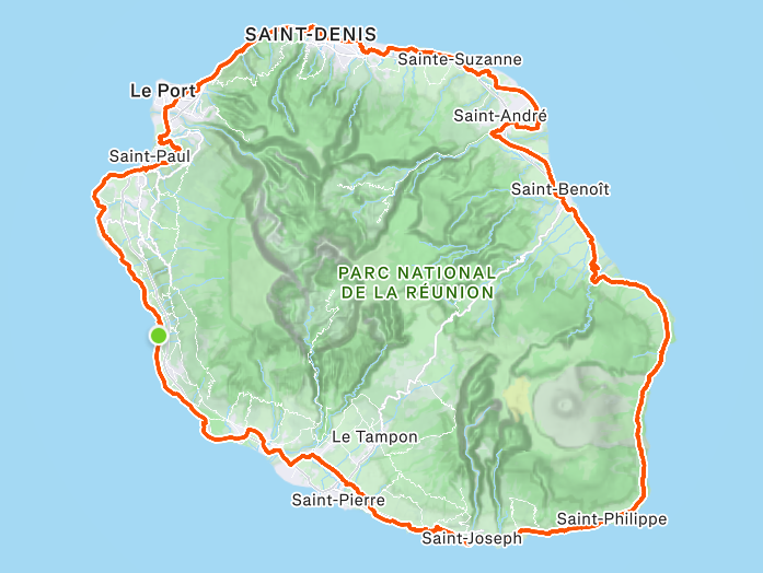
Bike — 233km
To kick off your day, you'll set off on the legendary 233km loop around the island of La Réunion.
A UNESCO World Heritage site, you'll ride between sea and mountains, never far from the Indian Ocean — the sea on your right, and on your left our volcanoes rising above 3,000m.
In a single day on the bike, you'll have the privilege of riding through the wild south (Sud sauvage), the lava road (route des Laves), then the sugar cane and lychee fields, the Route du Littoral, Cap Lahoussaye and finally the beach road (route des Plages).
View on Strava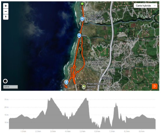
Run — 3 laps of 10km
Most of you will be lucky enough to watch the sunset during the run. When the sun touches the horizon, you'll have just 2 min 30 left before it disappears... so take your time for a little break :-)
You'll start each lap with a long 2.3km straight along the seafront towards Pointe au Sel. Watch out — the sun can be fierce in the afternoon, but with a bit of luck a small swell will come up and you'll be able to watch a few surfers on the "cimetière" wave; otherwise, there's always the beach to admire.
Then you head under the main road for an out-and-back towards the cemetery via la Savane. On the way back, you'll pass under the other little tunnel to reach the houses of Pointe au Sel. To round off this scenic tour, you'll loop around the salt-marsh visitor centre at Pointe au Sel. From there, you take the cycle path along the main road back to Saint-Leu... and of course, the whole thing is to be done 3 times.
View on Strava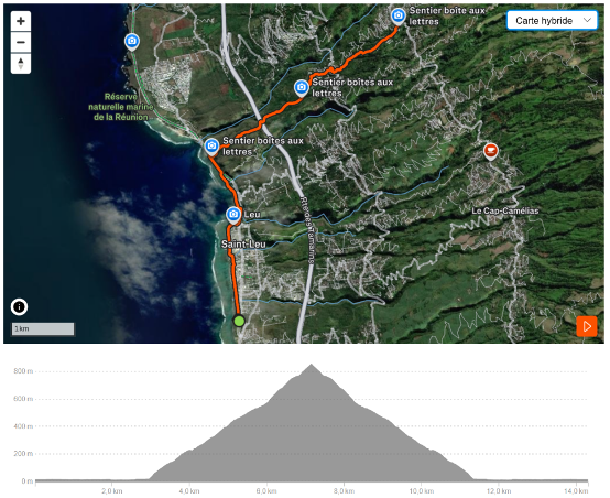
ULTIMATE loop — 14km / 850m+
For those who still haven't had enough, we've kept it simple :-) ... a little extra out-and-back up to CD3 on the TEMOR, a.k.a. the Sentier Boîtes aux Lettres.
Starting from the transition area, you cross town along the harbour promenade, then after the ravine you take the coastal path to the pedestrian crossing opposite the Boîtes aux Lettres trail. From there you'll tackle a trail that's legendary among local trail runners, the TEMOR (which stands for "Test en MOntagne Régulier") — 4.2km for 850m of elevation gain.
You'll start with a staircase section through the houses, then a fairly technical trail into the streets of Bras Mouton, then another kilometre of technical trail before finishing with the final tarmac wall: 330m at 90m+ with several sections over 30%!!! That one bites on the way up and bites again on the way down :-)
An aid station awaits at the Bras Mouton school at km 6 (550m+) on the way out and km 8.6 (850m+) on the way back. Once you reach the turnaround... all that's left is to do the same on the way down — certainly not the easiest part, watch out for cramps!
View on Strava